

Lobawn [Luban]
Good walks are even better shared.
S9797 : Lobawn summit, Wicklow Mountains & fallen boundary marker
Colin Park Photo source
Overview
Lobawn [Luban]
Nestled in the Blackstairs Mountains, Lobawn, standing proudly at 595 meters, beckons hikers and outdoor enthusiasts alike with its enchanting landscapes and challenging routes.
Geology
The rugged terrain of Lobawn is primarily comprised of Old Red Sandstone, providing a solid foundation for the variety of flora that flourishes here. As you hike, take a moment to appreciate the layers of history in the rock beneath your feet!
Routes
Lobawn Loop
This 8 km circular route provides an accessible yet invigorating hike. Expect to take about 3.5 hours to complete, and enjoy the moderately challenging terrain that will keep your heart (and your hiking companions) racing.
Scarred Glen Route
If you're in the mood for a tougher adventure, tackle the Scarred Glen Route. This 6.5 km trail challenges you for about 4 hours but rewards with stunning views and the feeling of conquering something truly special.
Summit Features
Upon reaching the summit, you'll not only be greeted by a substantial cairn that marks your achievement but also by panoramic views that make every step worthwhile. Don't forget to snap a picture; your Instagram followers will thank you!
Terrain Type
Expect a mix of grassy slopes and strategic rocky outcrops, along with a few boggy spots that add character—and occasionally a boot-testing challenge—to your trek.
Views
From the summit, take in sweeping vistas of the Wicklow Mountains to the north and the charming hills of County Carlow. The best season to visit is during late spring or early autumn when the weather typically cooperates and the colours are spectacular.
Hazards
While Lobawn is inviting, it’s wise to stay cautious. The trails can be slippery, especially after rain, and the weather can change faster than you can say 'do I need my rain jacket?'.
Nearby Summits
After conquering Lobawn, consider visiting nearby peaks like Mount Leinster and other majestic parts of the Blackstairs Mountains to extend your adventure!
Access
The trailhead is conveniently located near Bunclody, making it easy to enjoy a lovely day outdoors. If you're using public transport, check the latest schedules because they can be a bit willy-nilly at times.
Facilities
Once you're back down, treat yourself in one of the local cafes or pubs in Bunclody—after all, a legendary hiking tale deserves a legendary meal!
History
Lobawn, with its charming name derived from the Irish for 'little hill', is more than just a pretty face. Its cultural significance and storied past make it a must-explore for any enthusiast.
Conclusion
In summary, Lobawn is a rewarding hike for those looking to enjoy a beautiful mountain experience. Bring your sense of adventure, and maybe an extra pair of socks for those boggy spots. Happy hiking!
Explore routes near Lobawn [Luban]
Walks starting near this hill. Open a route to check its map, distance and full itinerary.
Route planning notes
These notes describe possible approaches. Check a route's map and access information when planning your walk.
Lobawn Loop
A scenic circular route that takes in stunning views and enjoyable terrain, suitable for most walkers.
Scarred Glen Route
A more challenging ascent that winds through the beautiful Scarred Glen, ideal for those seeking adventure.
Make a day of it, together
Find someone to share the walk with, or organise a day out along a route you like.
Photo Gallery
View all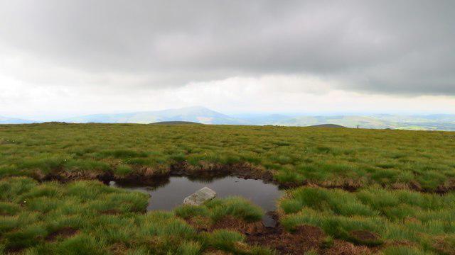 Photo could not load
S9797 : Lobawn summit, Wicklow Mountains & fallen boundary marker
Colin Park
Hill facts and local notes
Classifications
Elevation
637m
2,090 ft
Prominence
108m
Coordinates
53.0214, -6.5433
S978977
OS Map
56
At the Summit
The summit is crowned with a substantial cairn, offering a great spot for a quick breather and a panoramic view.
Terrain & Geology
The mountain is primarily composed of Old Red Sandstone with a rich tapestry of heather and bracken covering its slopes. The unique bedrock formations contribute to varied soil types, creating a diverse mountain ecosystem.
Views & Scenery
From the summit, enjoy views of the distant Wicklow Mountains, Blackstairs Ridge, and the rolling hills of County Carlow.
History & Heritage
Name Origin
Lobawn is derived from the Irish 'Luban', meaning ‘little hill’ or ‘small knoll’, which amusingly can be a bit misleading given its scenic elevation.
Historical Significance
Historically, the mountain has served as a significant landmark in local folklore and a training ground for the local walking and mountaineering clubs.
Getting There & Facilities
Parking
Parking is available at the base of the Lobawn Loop trailhead, which accommodates several vehicles but can fill quickly on weekends.
Public Transport
Bus services from Carlow to Bunclody operate, but check schedules as they can vary. A short taxi ride would be needed from the bus stop to the trailhead.
Nearby Facilities
Both Bunclody and nearby Barrowhouse provide amenities such as cafes, pubs, and public toilets.
Safety Information
Known Hazards
- Beware of slippery rocks and muddy paths, particularly after wet weather. Be cautious of sudden changes in weather.
General Safety Tips
- Check weather conditions before setting out
- Carry appropriate clothing and equipment
- Let someone know your planned route
- Take a map, compass, and GPS device
- Carry emergency supplies: food, water, first aid kit, torch
Hills
Some common questions about the hills answered
Are there group walks up Lobawn [Luban]?
Many walkers use Walkmates to join or organise walks with others. You can check for group walks around Lobawn [Luban] through the maps
Are there other walkers around Lobawn [Luban]?
Activity varies by location and time, but Walkmates lets you see whether others have shared walks or shown interest in this area. Find other people through the walking friends search walking friends for Lobawn [Luban] search or of course create your own walk for Lobawn [Luban]
Can I organise a walk to Lobawn [Luban]?
Yes. If there aren’t any walks listed already, you can create a walk and make it available for others to join.
If you're signed up to Walkmates, you can create a walk to Lobawn [Luban].
How do I find a walk up this hill?
There are often multiple ways to walk this hill, depending on experience and route preference. Walkmates helps you explore walks and routes that others have shared.
Can I suggest a new route up Lobawn [Luban]?
Yes. You can suggest or create routes to share with others. Walkmates focuses on the social side of walking, so routes are used to help people organise walks and explore areas together, rather than as detailed navigation tools or route libraries.
Other uses really appreciate knowledgeable walkers sharing their routes. Share your favourite route to Lobawn [Luban] here
The is an error or something incorrect about this hill. How do I let you know?
We always strive to keep the information on Walkmates as accurate as possible. If you find an error, please let us know through the contact form and we'll aim to correct it as quickly as possible
Community Discussion
Comments
Location
![Lobawn [Luban] location map](https://cdn.walkmates.com/hill-maps/hill-sources/20186/53.02137_-6.54331.png)
Grid reference: S978977
View on OpenStreetMapOpens a map in a new tab, centred on the hill.
No comments yet. Be the first.